Advanced 3D Reality Capture
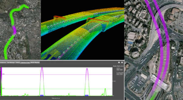
Construction projects, on road or rail infrastructure, or building projects, growingly benefit from 3D Realty Capture. In addition to the surveyor’s work, a complete 3D view or the construction site is now available on every desktop for analysis, change detection, and further planning. Drone-based data collection can be used to calculate differences over time, mobile mapping is ideal for infrastructure pre-planning, milestone checks, and as-built delivery. The number of applications is as diverse as the surveyor’s traditional work.
Construction Sites
3D Reality Capture in various ways has great value for any construction site projects : Mobile Mapping, Drone Mapping, Aerial Mapping, Static scanning, they all add to create an exact virtual 3D map of the site.
Analysis and planning are key applications for 3D content for quite some time. But also updates and an as-built data collection has increasing value. Especially the latter is valuable for the end customer, whereas intermediate scans can improve communication on the progress of the project.
Construction sites are by default projects that need fusion of a variety of sources and hardware instruments. Using a platform that can digest all of them is a key requirement for proper operation and integration.
Surveying and Assets
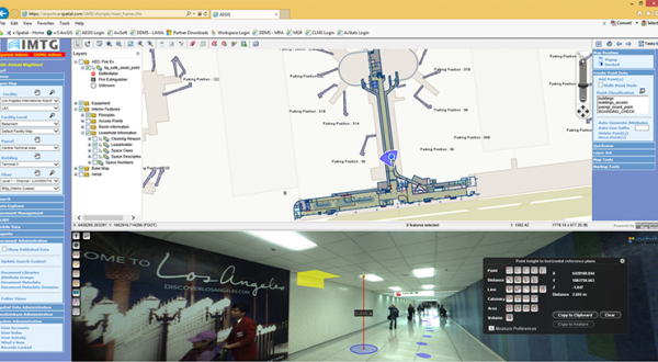
Top of the list in using 3D Mapping content is the requirements for Asset Inventory and Management. Especially 3D Mobile Mapping helps the contractor and surveyor to rapidly collect all streetside assets, while the surveyor can now focus on the key precision tasks. Mass data collection allows for rapid collection and processing, and have a team equipped with desktops perform precise feature extraction to fill an asset database. QC procedures guarantee a much higher satisfaction rate from the customer.
Forget safety issues or long manual asset collection: mass data collection is the new normal.