At the Esri User Conference Orbit GT is presenting its superb solutions to integrate streetlevel imagery and point cloud in the Esri portfolio. We will present our widespread and strong industry supported Mobile Mapping plugins in ArcGIS, ArcGIS for Server, and Latitude GeoCortex. Furthermore, we will highly focus on our newest and promising ArcOnline integration: the primary way to use Mobile, Terrestrial, Indoor, UAV and Oblique Mapping data within the Esri ArcOnline product.
Being experts in the management of big data in domains of Mobile Mapping, UAS Mapping, Oblique Mapping and Indoor Mapping, it is our strong belief that anyone using large volumes of point clouds and/or imagery will be thrilled by this product. The flexible, versatile, and hardware neutral solution is exactly what many organizations have been waiting for. The Orbit GT solution for ArcOnline is the perfect way to exploit vast volumes of 3D Mapping data, typically collected as LiDAR or Image data, in ESRI products. This product brings the ease of sharing, re-use, fusion or sources and integration of petabytes of data accessible for everyone in the business, from high-end engineering point cloud streaming to publishing up-to-date imagery for the public at large.
Check out www.3Dmapping.cloud.
Visit us for the Esri UC Expo at the San Diego Convention Center
Tuesday July 9th: 9:00am – 6:00pm
Wednesday July 10th: 9:00am – 6:00pm
Thursday July 11th: 9:00am – 1:30pm

111 West Harbor Drive
San Diego, CA 92101
United States
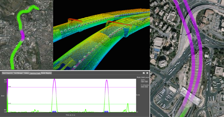
Tech Focus: Mobile Mapping a 600m tunnel in Israel
Photogrammetry is one of the most fundamental task’s Ofek Aerial Photography is doing on a daily basis. In almost every aerial mapping mission, there is a need in ground survey to complete the sampling of obscured objects ...