GEO Business is shaping up to be one of the most important shows in the geospatial calendar, with 3000 international visitors expected to attend. Orbit GT hosts a booth and shows its version 17.1 desktop solutions for Mobile Mapping, Indoor Mapping, UAS Mapping and Oblique Mapping. Orbit GT will be presenting on Tuesday May 23rd (ROOM 4, 10:15 am) focusing on its newest product “3D Mapping Cloud”: the primary way to share Mobile, Terrestrial, Indoor, UAV and Oblique Mapping data, via any browser, any platform, via plugins and integrations in any 3rd party application.
Being experts in the management of big data in domains of Mobile Mapping, UAS Mapping, Oblique Mapping and Indoor Mapping, a cloud based product is the logical next step. It is my strong belief that anyone using large volumes of point clouds and/or imagery will be thrilled by this product. The flexible, versatile, and hardware neutral solution is exactly what many organizations have been waiting for.
The 3D Mapping Cloud is a self-managed solution to exploit vast volumes of 3D Mapping data, typically collected as LiDAR or Image data. This product brings the ease of sharing, re-use, fusion or sources and integration of petabytes of data accessible for everyone in the business, from high-end engineering point cloud streaming to publishing up-to-date imagery for the public at large.
Check out www.3Dmapping.cloud.
Visit us at Stand N6
Business Design Centre
London, UK
Tuesday May 23rd: 9:00am – 6:00pm
Wednesday May 24th: 9:00am – 4:00pm

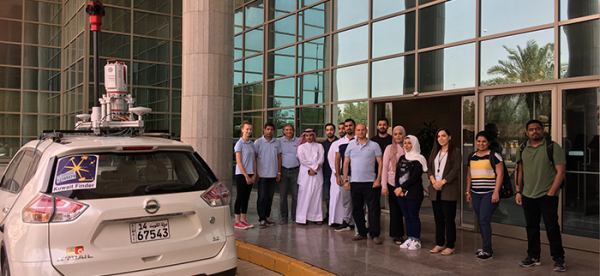
Bringing 3D Mapping to the people of Kuwait
In the past, people in Kuwait struggled to find a specific building. The Public Authority for Civil Information (PACI) intervened, inventing an address system that is unique in the world: The ‘Kuwait Finder’, an application for the public, governmental and private sectors. PACI now intends to also provide a full 3D map service for the country, which will allow users to see the streets of Kuwait in realistic 3D panoramic ...
Read More
Read More
It is very important for us to empower our Kuwaiti national youth with the knowledge and expertise about this new technology to the level at which they become a national reference in this high tech.
Upcoming events
No posts found.