
Orbit GT will be launching its disruptive 3D Mapping Cloud solution at SPAR, Houston.
“Orbit GT has been preparing for a cloud based SaaS product for over 2 years”, says Peter Bonne, CEO of Orbit GT. “Being experts in the management of big data in domains of Mobile Mapping, UAS Mapping, Oblique Mapping and Indoor Mapping, a cloud based product is the logical next step. It is my strong belief that anyone large volumes of using point clouds and/or imagery will be thrilled by this product. The flexible, versatile, and hardware neutral solution is exactly what many organizations have been waiting for.”
The 3D Mapping Cloud is a self-managed solution to exploit vast volumes of 3D Mapping data, typically collected as LiDAR or Image data. This product brings the ease of sharing, re-use, fusion or sources and integration of petabytes of data accessible for everyone in the business, from high-end engineering point cloud streaming to publishing up-to-date imagery for the public at large.
At SPAR, Orbit GT will launch the new SaaS product. Join us at our pre-conference session on Monday Apr 3rd at 11:30 am, visit us at booth 619, or check out https://www.3dmapping.cloud
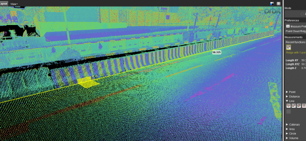
Autonomous vehicle maps in Singapore
GPS Lands Singapore took on an initiative to produce a highly detailed map for an autonomous vehicle testing area in Singapore using 3D Mobile Mapping system to collect the data and perform feature extraction using the 3D data ...
Using the 3DM Feature Extraction Pro allows semi-automated extraction of road features such as lane markings and curb lines, using the automatic detection of traffic signs and poles helps in identifying the location of all the traffic signs and traffic light poles where the operator is able to extract all the accepted detections.


