Orbit GT announces the launch of version 20.3 of its 3D Mapping portfolio.
We’ve skipped a few announcements, so it’s about time to wrap up and summarize what we have included in the latest releases.
As usual, you can check all the updates on our knowledge base and download the updates from our product pages on this website.
For 3DM Publisher and 3D Mapping Cloud, version 20.3 has been released today.
For all Desktop products, version 20.2 is available for download.
Desktop updates:
All desktop products:
-
User Interface Facelift: Simplification of main toolbar, menu access, and generalized map interactions.
-
Preset templates for new vector datasets
-
EPSG Reference Database update to the latest version
-
JDBC database drivers update
-
WMS resource configuration to ignore DCP
-
3D Tiles resource driver update to support URI
-
Added Autosave 3D measurements
-
Copy spatial component of 3D Measurement to clipboard
-
Georeference Point Cloud, Edit Point Cloud Legend
-
Esc Button to reset active function to pan function
-
Web-based resources are set italic and grayed out in the dataset list on Map 3D to indicate the resource cannot be rendered on this Map View.
-
Selecting 2D Measurements triggers Map 2D, opening Map 3D will trigger 3D Measurements
-
Default point cloud legend is created to Convert and Optimize source Resource to target Orbit Point Cloud.
-
Add the Spatial Object ID as attribute “ID” if the exported dataset has no Attributes.
-
Open and remove run or project has been made a little easier as the search entry field is directly active to filter the list.
-
Keystrokes for mobile and uas mapping are applied on all opened views, and no longer on the first view only.
3DM Content Manager:
- Added Colorization of Point Cloud by Imagery feature
- Delivery, Clip and Export by Fence or Vector Dataset
- Delivery, Merge Runs without unique image file names
-
Post collection calibration for boresight or leverarm only
-
Script to Convert Vector Data
-
Script to Optimize Imagery
-
Ghost cleaning process using default DEM parameters.
-
Presentation of trajectory error value on the trajectory graph if the first trajectory timestamp has no error value.
3DM Feature Extraction:
-
Enhanced Pole attachment and Tree object-detection formulas
-
Pole attachment and Tree measurements now integrated for Asset Inventory
-
Attribute dependent value lists for Asset Inventory
-
Import and Add local vector dataset to Inventory Theme
-
Detector preferences are visually grouped.
-
Labels and Buttons in the Verify section of Automated Feature Extraction Extension have been updated to be consistent to the linked Asset Inventory Procedure.
Publisher and 3D Mapping Cloud updates :
-
Textured Mesh: enhanced support for Cesium format
-
Slice View: New sidebar to create Vertical, Horizontal and Free Slices based on the 3D Point Cloud View.
-
Image Play Function: Set speed of play function: Slow, Normal and Fast via Viewer Settings.
-
Measurement Downloads: Additional download formats for saved measurements: WellknownText, GeoJason, and Kml.
-
Fly Sidebar: Redesign and update of the 3D View fly-through. 3D Fly-paths can be exchanged between Orbit desktop and Cloud.
-
Geocoding Search: Clear and autocomplete using Google geocoding search.
-
Synchronize View includes follow zoom.
- Resource Groups now handle large lists of Resources dynamically.
- Guest Users, save login for quick access
-
Guest Users and Named User, auto-close for opened sessions
-
Open Image, best and next best image
-
Resource Footprints, set color
-
Textured Mesh, enhanced support for Cesium format
-
Annotations can now use custom symbol url
-
Focus View Action added to focus and synchronize all other views to the Active View.
-
Added a View Ground Height in supplement of a Reference Ground Height to optimize display of 2D vector data.
-
Synchronize Views by Reference View
-
Synchronize Views by Focus Coordinate instead of View Coordinate to Synchronize Views if the Field of View of Active View is represented by an area.
- Synchronize View includes Follow Zoom
-
Added Localized geocoding service support for certain regions.
- Display Coordinate system (CRS) in measurement results
-
Publisher: Custom Help menu item
-
Publisher: Custom Viewer menu item to open 3rd party application
- Publisher: Simplified publication URL scheme
- Publisher: Added 3D Models in Annotations
- Console: Publication Statistics: View the usage statics of Named and Guest Users by the hour, day, week and month.
- Console: User Management: Redesign of User invite and management pages. Invite multiple users at once. Avoid sending invite confirmation mailing.
-
Console: Handling large pages: Improved performance and organization of large pages. Maximum 50 records displayed by page.
- Publications: Add dedicated logo
-
Various usability and UX improvements
- SDK and plugin updates
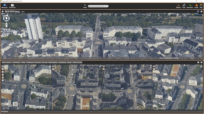
Top image showing reality mesh and aerial oblique imagery in 4 directions (c) BeMap Solutions.
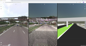
Center image showing image, point cloud and BIM model in Singapore (c) GPS Lands

The Isle of Man: TT race mobile mapped for highway asset management and gaming
When LandScope Engineering was commissioned by the Isle of Man Government to accurately map both the TT and Southern 100 routes for the purposes of highway asset inventory and visualisation and to meet future 3D gaming and simulation requirements, a compelling and innovative solution was required ...
Read More
Read More
This innovative approach brings benefits in that one campaign may satisfy many different objectives.