Orbit GeoSpatial Technologies is pleased to announce the launch of the Mobile Mapping plugin for AutoCAD MAP.
“We’re pleased to announce that from today, every AutoCAD user now has access to the vast volumes of Mobile Mapping data”, says Peter Bonne, CEO of Orbit GT. “By connecting to our Publisher, the AutoCAD MAP user consumers spherical imagery and point cloud data of unlimited volume and size right onto the desktop.”
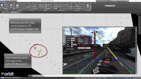
With the Orbit GT plugin for AutoCAD MAP, the use of native Mobile Mapping content becomes very easy. Any challenge of volume and performance is tackled by the Orbit Publisher. Users can simply measure, copy any measurement into AutoCAD Map, and overlay AutoCAD Map features on the Mobile Mapping imagery. Very powerful indeed!
Have a look here : https://youtu.be/JYNjYZGX-t4?list=PLE9Z5YdkIco96GACTmb_9zl8GOkRTk6MO

Michael Baker and BPG Designs optimize workflow and processes for Telco Industry
Mobile technology has changed the way humanity navigates its future. In the palm of our hands we are now integrated with all the people we know and don’t know through social media applications, we have integrated our work spaces with our home, and we can even track our geographic position and plot the quickest route to work. Why are we not as successfully integrated at work when it comes to ...
Read More
Read More
Orbit did not drive, or change our workflow. Instead, it nestled itself right into all aspects of it, and some places that we did not even anticipate.


