Orbit GeoSpatial Technologies announces the launch of the Orbit Mobile Mapping portfolio version 17, at Intergeo, Hamburg, taking place October 11th-13th 2016. Visit booth C4.039 in Hall 4.
“We are very happy to make version 17 available”, says Peter Bonne, CEO of Orbit GT. “Version 17 brings many improvements and some striking innovations, such as automated feature extraction. Launching at at Intergeo, the globally largest event in the Geobusiness, brings supplementary momentum to our portfolio and over the years has become a good habit.”
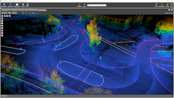
The Mobile Mapping Version 17 release focusses on the improvements for the Content Manager, a necessity for data capturers, and innovations for Feature Extraction, such as parallel extraction, curbstone and ridge detection, wire detection, road markings and rail detection and many more.
Watch the latest video’s of Content Manager v17 :
IMPORT : https://www.youtube.com/watch?v=sbWffGOyyps
EXPLORE : https://www.youtube.com/watch?v=cJAKGPofzik
VERIFY : https://www.youtube.com/watch?v=Pez2Ea15hN4
ADJUST : https://www.youtube.com/watch?v=iqNOstVTwbE
DELIVER : https://www.youtube.com/watch?v=WazbVcCNGCM
Version 17 will be available for the Mobile Mapping portfolio by October 1st, followed soon by version 17 for the Oblique and UAS portfolios.
Michael Baker and BPG Designs optimize workflow and processes for Telco Industry
Mobile technology has changed the way humanity navigates its future. In the palm of our hands we are now integrated with all the people we know and don’t know through social media applications, we have integrated our work spaces with our home, and we can even track our geographic position and plot the quickest route to work. Why are we not as successfully integrated at work when it comes to ...


