We find ourselves in the age of big data, often brought in the context of IoT. And rightfully so : the countless devices in IoT generate massive amounts of little pieces of information. Data mining has become the new normal and is feeding analytical algorithms, machine learning, deep learning, and AI. Cool stuff.
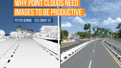
In our geospatial business, I tend to associate the term Big Data with something else : not countless pieces of small data, but the other way round : sets of homogeneous but massive data. Like a LiDAR point cloud. It’s not the individual point that makes the difference, it’s the fact that you have so many of them that allow you to build up a representation of reality on your desktop.
Laser scanning is not new, nor is (aerial) photography. But the last decade has seen exponential growth in resolution, density, and in the adoption of these technologies. So now every geospatial professional generates massive datasets in a second. This would be impossible without the parallel evolution in storage, cloud services, and processing power.
Today, every surveying team has closets full of xTB drives with data from y projects. No doubt the data has been useful. But what’s next ? Here’s some insight I want to share.
No doubt in my mind that 3D mapping is going to be the standard in mapping. Do we get rid of 2D ? No, that’s still very useful for many applications. But the 3D map is here to stay, and find its way in a growing number of applications and workflows. There’s no return. The coming-of-age of 3D data capture has been fueled by AEC : these domains simply can’t do without. But AEC typically is project-based. Mapping typically is process-based, an ongoing process, a never-ending story. Copying project logic into processes is not such an obvious thing to do, so we need to re-invent the 3D data capture, management, and usability to become applicable for 3D mapping.
To collect 3D mapping data, we can now choose or combine imagery and lidar data captured by airplane, drone, car or other mobile vehicles. We can derive point clouds form densely matched imagery, build fine and sharp models or textured meshes and so on. One may think that these processes are today’s state-of-the-art technologies and its data processing is a challenge to be met. This is only partly true, as we see that the current state of these processes shows margin for continued improvement. It is my view that the real challenge lays beyond that.
As 3D mapping will become a standard for cities, transportation authorities (road and rail), facility management, utility management, autonomous vehicles and many more industries and government departments, its challenge to keep up with reality will become much more important than a 2D map ever was. As the management of our living environment is increasingly becoming Smart, it can only do that with proper data. Hence up to date. The management of 3D mapping content is inevitably vital for any organization to become Smart by its very nature.
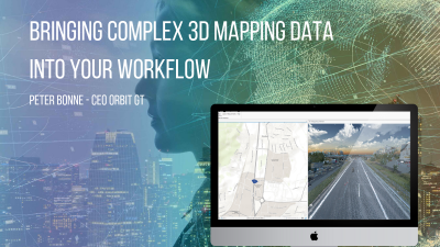
Content Management is a verb (credits to Gerry Ong). It’s the place where you manage the 3D map, filter, optimize and QC incoming updates to be deployed for usage downstream. When we at Orbit GT initiated our Content Manager product, this was exactly what was laid on the table : manage, QC and optimize incoming new 3D mapping content, and make it ready for further usage. That usage downstream is quite different from the AEC requirements. In AEC projects, engineers define the specs for 3D data capture, process for accuracy and other QC parameters, and use that dataset in specialized tasks. End. There’s no downstream. In 3D Mapping, on the other hand, the usage downstream is separated from the data capture process. So there are different standards to be applied to define specs, capture, process, manage, QC and optimize this content. The multi-use of 3D mapping content is a no-brainer as, equal to the 2D map, it is being integrated into daily processes and routines as we speak. So the person or algorithm using this data, must be able to rely on its quality – the user cannot go back to the surveying team to ask for an explanation, it simply has to be right. And as more and more processes rely on this 3D data, and Smart management becomes the standard, it has to be up to date as well.
Remember when you embark on a 3D mapping voyage : Content Management is key to your success.
https://www.linkedin.com/pulse/why-content-management-key-success-3d-mapping-peter-bonne
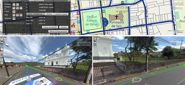
Vista 360: The digital transformation of Street Management in Costa Rica
One of the most important tasks of municipalities is managing their territory. This task is a daily challenge, because there are many variables: the maintenance of streets, sidewalks, piping, signage, trade, education, housing and factories. Not to mention the constant search for a balance between the quality of life of citizens and a responsibility for the environment ...
It has always been a challenge, not just to take daily measurements in order to take effective actions, but also to properly record these measurements.