Orbit GT will exhibit at the joint ILMF and ASPRS conference Denver, CO.
“Coming home to ILMF is a great yearly event. It’s my pleasure to announce the latest version of Orbit 3D Mapping Feature Extraction Pro, our top product with fully automated extraction tools, from Street Level Mobile Mapping to Aerial Oblique Imagery.”, says Peter Bonne, CEO of Orbit GT. “As reality capture techniques evolves and data volumes grow, so does the need for tools that can disseminate and share these large volumes. That’s exactly Orbit GT’s top expertise. No more time to waste on tiling and partitioning.”
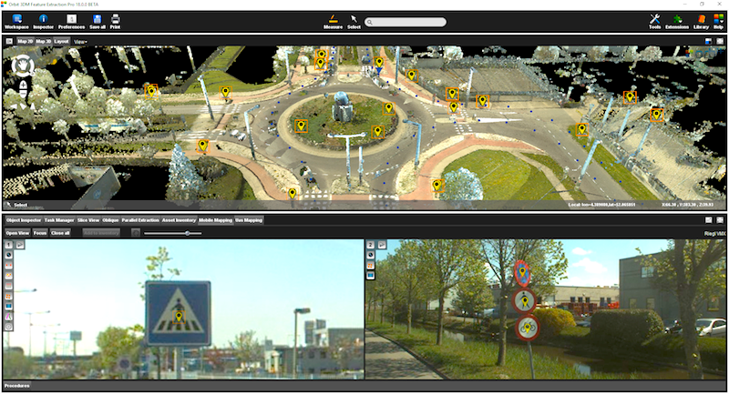
As the current version 18 bundles all the expertise and technology to support the various types of 3D mapping techniques, street level Mobile Mapping can be instantly combined with Aerial Oblique, UAV and Terrestrial data collection, offering rich data analysis capabilities. Semi- and full auto detection tools speed up conversion of raw 3D capture data to actionable information in DOT’s day-to-day operations.
Come visit us in booth 600 or reserve your time slot on http://orbitgt.com.pages.services/2018-q1-ilmf-conference
In the image : Auto detected traffic signs, with snapshots from imagery, and registered anchor points in the GIS/CAD database.
As we experience many of Orbit GT customers are using several techniques of reality capture, such as Mobile Mapping, Terrestrial scanning, Aerial Oblique and UAS Mapping, we worked towards an integration of our portfolio to offer a single product line covering the needs for each of these domains. This native integration is a sure win for every customer and user.
Michael Baker and BPG Designs optimize workflow and processes for Telco Industry
Mobile technology has changed the way humanity navigates its future. In the palm of our hands we are now integrated with all the people we know and don’t know through social media applications, we have integrated our work spaces with our home, and we can even track our geographic position and plot the quickest route to work. Why are we not as successfully integrated at work when it comes to ...
Read More
Read More
Orbit did not drive, or change our workflow. Instead, it nestled itself right into all aspects of it, and some places that we did not even anticipate.


