
Orbit GT is pleased to announce that eagle eye technologies GmbH, Germany, has joined as Authorized Reseller of Orbit GT 3D Mapping products.
“We’re very pleased to announce eagle eye technologies as our Reseller”, says Peter Bonne, CEO of Orbit GT. “eagle eye is a well known and experienced player in the german mapping industry. We’re looking forward to a great co-operation and take solutions for our joint customers to a next level.”
“We are very happy about the partnership with the Orbit GT team and the successful integration of the eagle eye data”, says Dr. Johannes Ludwig, managing director of eagle eye technologies. “With the modern and innovative products from Orbit, our high-quality and precise image and scan data can now be optimally visualized and used on the web for our customers.”
About eagle eye technologies GmbH
The fastly increasing demand for current and complete road database in many applications is a great challenge to the traditional geodetic services. The biggest problem is data acquisition. The information needed is expensive to obtain by traditional methods like aerial photogrammetry and terrestrial surveying.
The eagle eye technologies has been designed to collect road related data in a cost-effective way. eagle eye technologies defines the state of the art in mobile mapping technology by producing image and laserscanner data from a vehicle moving at highway speeds. eagle eye technologies is the answer to the challenge of quick updating road database. The eagle eye system architecture is modular and consists of basically two subsystems. The trajectory system supplies a 3D-position and orientation of the vehicle in space provided permanently by an inertial measurement unit (IMU), two differential GPS and odometer data. Precise synchronization of all sensors with a common time reference links the different modules to the trajectory, which is absolutely necessary to obtain optimum accuracy of data acquisition. The object data subsystem consists of several photogrammetric CCD cameras, digital documentation videos and laserscanners. This system can be used to selectively update road database precisely, rapidly and in economical way.
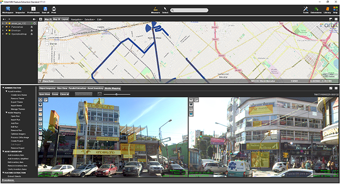
La Matanza, Argentina, optimizes public advertising using Mobile Mapping
The survey and identification of public advertizement space for the calculation of the advertising rights of La Matanza allows the city to quantify and typify all the installations and/or advertising elements through which the economic activity of a certain social actor is developed and materialized according to the ordinance tariff 2017 for the advertising rights of the municipality of La Matanza ...


