“Orbit UAS Mapping v17 is a milestone release for Orbit GT”, says Peter Bonne, CEO of Orbit GT. “This release will put Orbit GT back on the map in the UAS Mapping business. Many UAS users are lacking a powerful feature extraction tool, and this is where Orbit UAS Mapping brings relief. Another major element is the splendid support for any combined image and point cloud dataset, with native import from Pix4D, Agisoft, RiPrecision UAV and many more. If you’re visiting the Commercial UAV Expo, get your discounted copy now.”
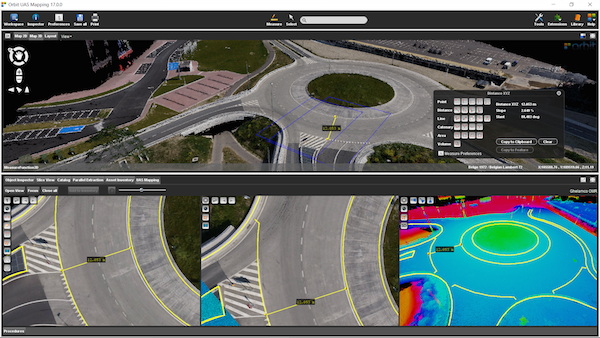
UAS Mapping version 17 now offers seamless support for both imagery and point clouds, either LiDAR or dense-matched. The powerful Feature Extraction tools offer the same flexibility and precision as Orbit’s Mobile Mapping portfolio : points, lines, areas, catenary wires, distances, and al load of superb semi-automated tools. On top of that, Orbit UAS Mapping includes Vector file overlays, GIS data integration, Asset Inventory workflows, Profile and Cross Section tools, Clash Detection, Volumetric Analysis and Contour Line generation. The screen image in this communication shows the point cloud in RGB, colorization according to height, and 2 individual aerial images.
Highlights :
- Unlimited image and point cloud support
- Import from Pix4D, AgiSoft, RiPrecision UAV and any other post-processed data delivery
- Seamless navigation in multiple synced views
- Show images and point cloud simultaneously.
- Slice Viewing
- Instant Overlay of vector data, GIS data integration
- Global support for CRS systems
- Positional Accuracy Verification using Ground Control Points
- Countless Feature Extraction and Measurement tools
- Semi-automated Feature Extraction tools
- Parallel Extraction, semi-automated
- Direct storage of extracted features in GIS and CAD formats, database
- Clash Detection
- Profiles and Cross Sections
- Volumetric Analysis and Change Calculation
- Contour Line Generation
- Fly-Through movie maker – standard movies and 360 degrees VR movies.
Orbit UAS Mapping v17 will be available for download from October 31st 2016.
Visit us in booth 619.

Bringing 3D Mapping to the people of Kuwait
In the past, people in Kuwait struggled to find a specific building. The Public Authority for Civil Information (PACI) intervened, inventing an address system that is unique in the world: The ‘Kuwait Finder’, an application for the public, governmental and private sectors. PACI now intends to also provide a full 3D map service for the country, which will allow users to see the streets of Kuwait in realistic 3D panoramic ...


