
“Orbit UAS Mapping v17 was successfully released just a few weeks ago at the Commercial UAV Expo in Las Vegas”, says Peter Bonne, CEO of Orbit GT. “Our discount action attracted many new customers which made us decide to extend the discount period up to December 20th. This will help even more users to get started quickly with this game-changing solution.”
UAS Mapping v17 discount first period ended November 22nd, now extended for a second period ending December 20th 2016.
UAS Mapping version 17 offers seamless support for both imagery and point clouds, either LiDAR or dense-matched. The powerful Feature Extraction tools offer the same flexibility and precision as Orbit’s Mobile Mapping portfolio : points, lines, areas, catenary wires, distances, and al load of superb semi-automated tools. On top of that, Orbit UAS Mapping includes Vector file overlays, GIS data integration, Asset Inventory workflows, Profile and Cross Section tools, Clash Detection, Volumetric Analysis and Contour Line generation. Take a look at the comprehensive video here :
https://vimeo.com/channels/mobilemapping/189673406
Highlights :
- Unlimited image and point cloud support
- Import from Pix4D, AgiSoft, RiPrecision UAV and any other post-processed data delivery
- Seamless navigation in multiple synced views
- Show images and point cloud simultaneously.
- Slice Viewing
- Instant Overlay of vector data, GIS data integration
- Global support for CRS systems
- Positional Accuracy Verification using Ground Control Points
- Countless Powerful Feature Extraction and Measurement tools
- Semi-automated Feature Extraction tools
- Parallel Extraction, semi-automated
- Direct storage of extracted features in GIS and CAD formats, database
- Clash Detection
- Profiles and Cross Sections
- Volumetric Analysis and Change Calculation
- Contour Line Generation
- Fly-Through movie maker – standard movies and 360 degrees VR movies.
Orbit UAS Mapping v17 is available for download today on https://orbitgt.com/uas-feature-extraction/#download
Up to date documentation is available at Orbit GT’s knowledge base : https://orbitgt.com/kb/uas_mapping
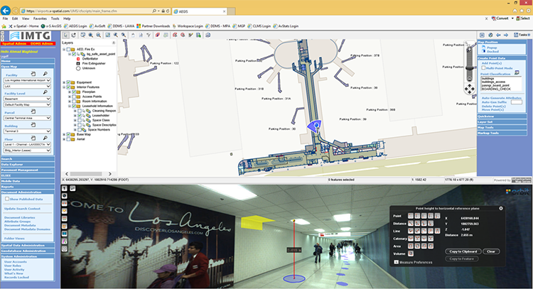
Indoor mapping at Los Angeles Airport: A Complex Spatial Story
Collecting and managing spatial data at airports is challenging. Just about everything in the airport needs to be tracked. From pavement management, runway markings and lighting to indoor space usage, equipment’s and signage, all of these need to be integrated with various environmental, safety, security, operational or facility and maintenance management tools ...


