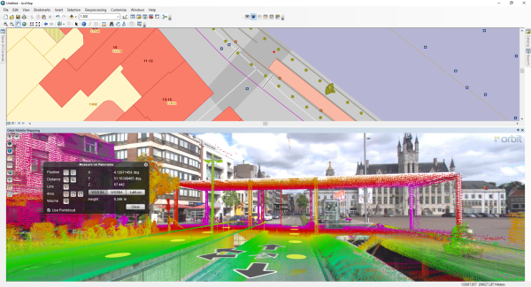
Orbit GeoSpatial Technologies launches the newest version of its Mobile Mapping plugin for ArcGIS for Desktop at the Esri Partner Conference, Palm Springs.
“Our long-available Mobile Mapping plugin for ArcGIS is now updated to its latest version 11.2, adding features made available by the latest Publisher update”, says Peter Bonne, CEO of Orbit GT. “At the upcoming Esri Partner Conference, we are demoing this new plugin and will have it available for download and purchase right after the show.”
The ArcGIS plugin tightly links Orbit GT’s Mobile Mapping technology with the ArcGIS for Desktop platform. Many different measurements can be made, and its results can be copied to create new objects in standard ArcGIS layers. Even so, all ArcGIS layers can be superimposed upon the Orbit Mobile Mapping view. This high end integration allows professionals around the world to embrace Mobile Mapping from within their familiar workflows. Come visit us in booth 104
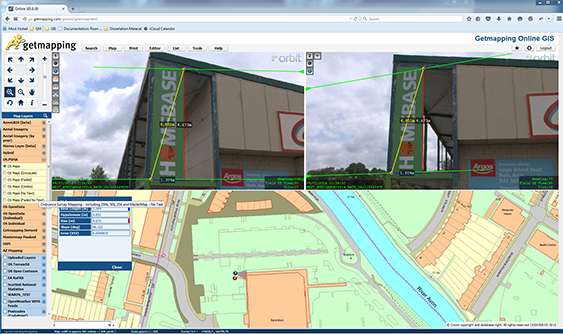
Getmapping provides UK with street imagery
Getmapping plc is a leading provider of aerial photography, mapping products and data hosting solutions in the UK and South Africa. Founded in 1998, Getmapping was the first organisation to create a complete photographic record of the UK, called the Millennium Map. Since then, Getmapping has expanded to provide Web Services (WMS, WFS, INSPIRE), hosted GIS and consultancy to a range of industries in the public and private sector ...


