
“Our seamless integrations throughout the Esri platform opens up powerful and efficient use of vast resources, such as huge volumes of Mobile Mapping, Oblique or UAS content”, says Peter Bonne, CEO of Orbit GT. “The Image Mapping Forum is a great place to show and present our newest products.”
Orbit GT’s new technology supports streaming of imagery and point clouds of unlimited size directly into ArcOnline. The technology makes Mobile Mapping, from Street Level Imagery up to the vast point clouds representing a complete city or corridor in full 3D, available from within any web page built with ArcOnline or the Web App Builder. It includes Orbit’s unique support for all and any mobile mapping system, introducing a first-of-its-kind standard for this type of content in the Geospatial Business.
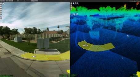
Optimized procedures for slope inventory in Phoenix, Arizona
The American Disabilities Act (ADA) recognizes the significance of a city’s pathway infrastructure and is set out to make certain they pose no barrier to the mobility-impaired pedestrian by implementing a Public Right of Way Accessibilities Guidelines (PROWAG) ...


