Challenge
According to US Census data compiled by the American Community Survey (ACS), population aged 65+ is growing at a higher rate than the total population by a ratio of 2.5:1. With the growth rate there will be an increased number of mobility–impaired individuals who will need to navigate public right of way paths with the same ease as the everyday motorist. Luckily, the American Disabilities Act (ADA) recognizes the significance of a city’s pathway infrastructure and is set out to make certain they pose no barrier to the mobility-impaired pedestrian by implementing a Public Right of Way Accessibilities Guidelines (PROWAG).
Solution
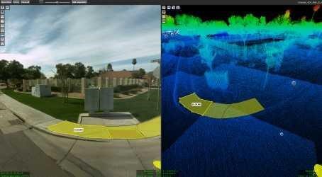
The evaluation called for BPG’s advanced, high-accuracy mobile LiDAR technology to be at the forefront of this project. BPG collected over 630 arterial and collector road centerline miles using the state-of-the-art IP-S3 mobile mapping system, creating a 3D model of the city’s street assets. The IPS3’s high density, high precision point clouds combined with high-resolution panoramas allow the Orbit GT user to access an array of data for the surveyed area.
Result
The most significant contribution that the scripts have made to the BPG process is that the projects are now consistent, repeatable, and we are able to provide detailed documentation with our results. The time savings, repeatability and documentation allowed BPG to provide an accurate, quality result for over 630 centerline miles that was delivered on time and exceeded the expectations of the clients. The city can now use the information to help improve the capability of its community to traverse the sidewalks and right of ways.