“We’re proud to announce that, with this release, our full portfolio has now been upgraded to version 18”, says Peter Bonne, CEO of Orbit GT. “As version 18 bundles all the expertise and technology to support the various types of 3D mapping techniques, all users of Mobile Mapping, Oblique Mapping, UAS Mapping, Indoor and Terrestrial Mapping, can now use a single integrated tool for managing and exploiting all of their 3D data. This is a true revolution in the 3D Mapping business, providing dramatic improvements in workflow efficiency and overall project management.”
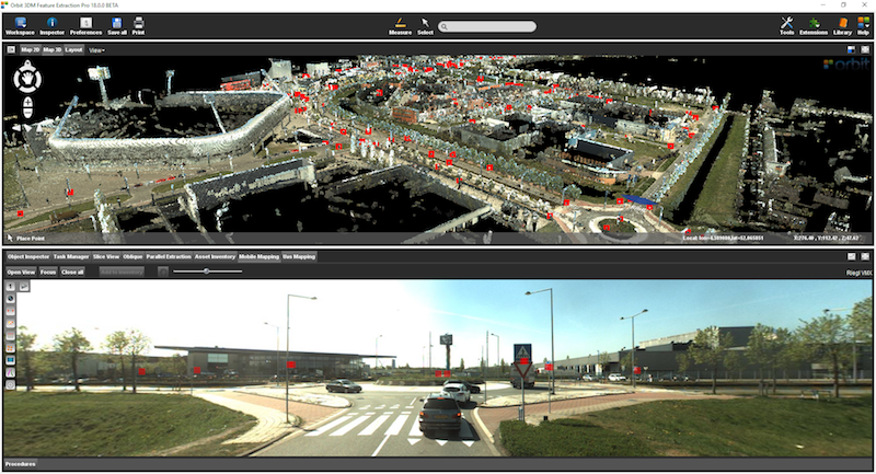
3DM Feature Extraction Pro is Orbit GT’s high end product, including a ton of tools to assist all users with ease of use, minimal learning curve, all-in-one solution, and assisting procedures up database connections and to QC tools. FE Standard is the workhorse for many 3D Mapping companies and government agencies and is leading the market for over 5 years.
Main new features are :
– full automated extraction of poles
– full automated extraction of traffic signs
– full automated classification of poles by use of a free to define object template
3DM Feature Extraction Pro is available for download today:
https://orbitgt.com/3dm-feature-extraction/#download
As we experience many of Orbit GT customers are using several techniques of reality capture, such as Mobile Mapping, UAS Mapping, Oblique Aerial, Indoor and Terrestrial scanning, we worked hard towards an integration of our portfolio to offer a single product line covering the needs for each of these domains. This native integration is a sure win for every customer and user.
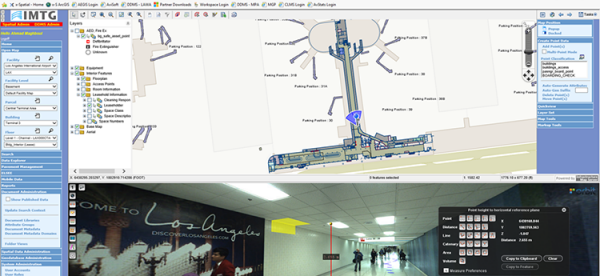
Indoor mapping at Los Angeles Airport: A Complex Spatial Story
Collecting and managing spatial data at airports is challenging. Just about everything in the airport needs to be tracked. From pavement management, runway markings and lighting to indoor space usage, equipment’s and signage, all of these need to be integrated with various environmental, safety, security, operational or facility and maintenance management tools ...
Read More
Read More
Orbit GT’s software and built in workflows have raised the bar of indoor mapping at airports.


